

MAIA PARK (2007)
Maia, Oporto, Portugal
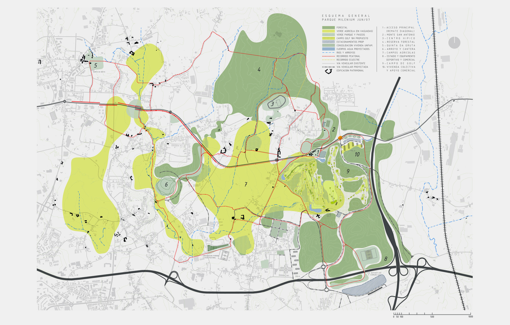
Maia Park design (“Milenium” Metropolitan Park, as designated by the Municipal Chamber of Maia) is framed within a set of interventions projected in the north strip of the municipality of Maia, along the road axis known as “Diagonal”. The main goal goalof the global Plan is to enhance the primary strengths of the territory – great mix / diversity of uses and green predominance – through restructuring and conservation measures, which guarantee a sustainable development in the short, medium and long term.
The nature of this new facility transcends the generalized conception of park as a large public green patch, like Central Park (NY). It is an open and flexible (evolutionary) concept that aims to integrate a network of routes through private domains that support the green and allows a free enjoyment of the landscape, sports and local culture.
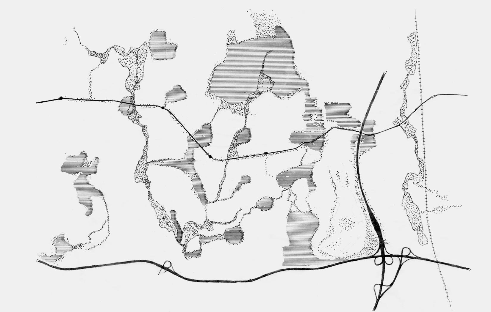
For this reason, the project development has required a reflection over the concept of territory voids: interstitial voids in “productive areas”, along with large “non-productive” voids related to wild natural areas and forest areas, which are not related to any type of exploitation. Both categories are equally important: the first for the dynamism and diversity of activities it involves; and the other for its permanence character associated with the promotion and conservation of natural habitats. In relation to the formation of the void, topography is a primary aspect that allows us to understand the occupation patterns of the site: ridges and elevated areas correspond to forests, troughs and low areas to agricultural productive areas and / or wild natural areas. The diagram of these extreme conditions gives guidelines to characterize and diagram the territory.
In short, the municipality has a great variety of very appropriate attractions to be integrated into the park network. Among this, it stadns out: A) Natural areas on stream beds and forest masses on elevated areas; B) Established poles of compatible activities, such as Quinta da Gruta, the recreational area located in Monte de San Antonio and the surroundings of the Equestrian Center and Parish Church (1791) of Silva Escura; C) Numerous constructions cataloged as historical heritage (houses, laundries, aqueducts and others); D) Fields of family agricultural exploitation of important landscape value; and E) Areas capable of incorporating new programs aligned with the park’s vision: golf course, new soccer stadium and sports center, commercial equipment areas, small parks and urban gardens.
Completely detached from the idea of a thematic park, and with the intention of allowing an easy identification of the scope of the proposal, it is plausible to point out eight sectors based on the most significant aspect in each of them, not without considering the mixture and the diversity as a constant in the territory: 1) Diagonal top off (access), 2) Monte San Antonio, 3) Equestrian Center, 4) Forest area, 5) Quinta da Gruta, 6) Stream and quarry area (possible conversion to park), 7) Agricultural fields and, 8) Stadium and golf course.
Finally, considering that this type of large-scale projects are settled down through iterative processes of slow accommodation over time, the general scheme refrains from setting strict limits to a territory that, despite its complexity and diversity, still retains the charm of a long rural tradition.
